World 🢖 North America 🢖 Canada 🢖 Quebec
Impact craters 🢔 Geological wonders 🢔 Categories of wonders
Wonder
Pingualuit crater (Chubb crater)
 In short
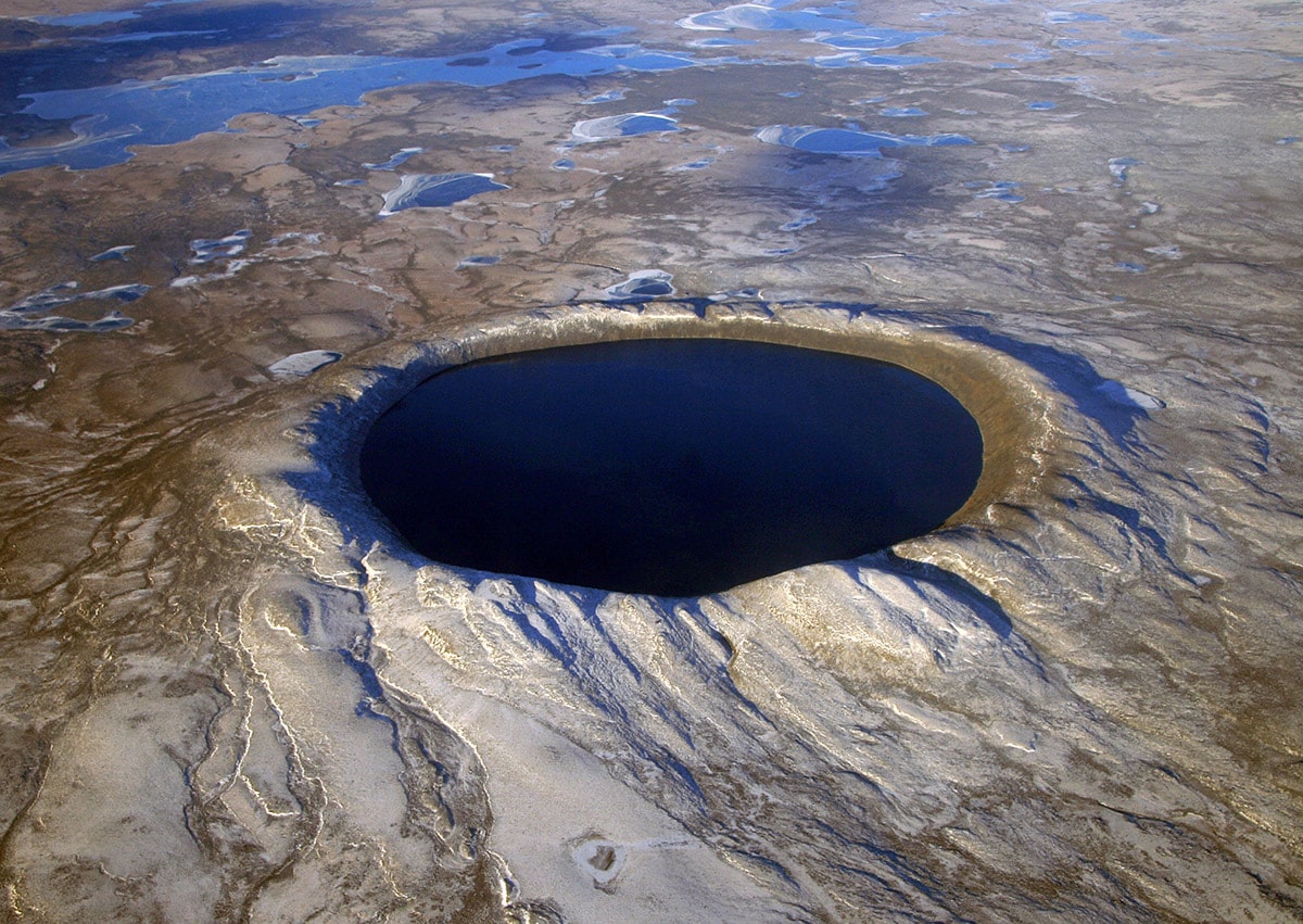
Ungava Peninsula has a true natural wonder – Pingualuit crater. This is one of most impressive impact craters on Earth, possibly – the most impressive one.
 56.8%
56.8%
GPS coordinates
Location, address
Name in French
Alternate names
Diameter
Depth
Age of the impact
Map of the site
If you see this after your page is loaded completely, leafletJS files are missing.
 In detail
Place of power
Local Inuit people knew well about this unusual lake. This eerie, unusually calm place was considered to be a site of extreme power, where one comes to revitalize himself.
The name given to it though is more prosaic. "Pingualuit" could be translated as the site "where the land rises", but this translation could designate also skin blemishes due to cold weather.
Discovery and research
White people learned about this lake rather recently.
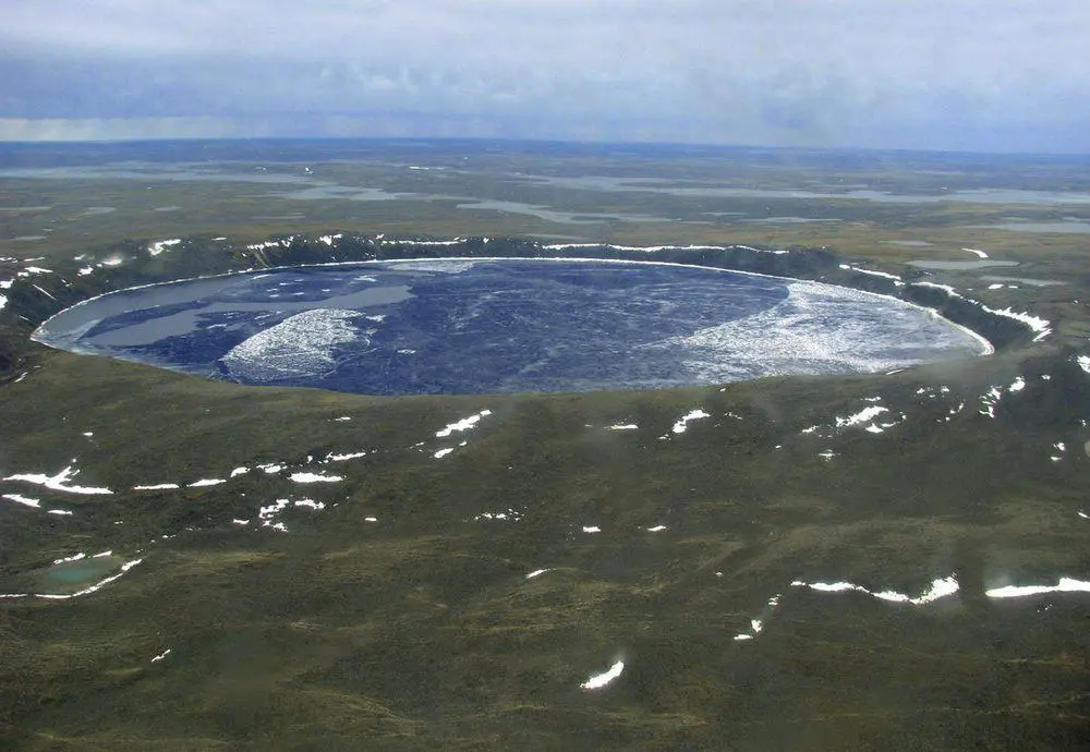
It is possible that the first ones to notice it were military pilots who used this unusual, round lake for navigation. In June 1943 was taken the first known aerophotographic image of the crater.
Diamond prospector Frederick W. Chubb learned about this unusual lake and became interested in it. He thought that this might be an extinct volcano and there is a possibility to find diamonds nearby.
He asked for the assistance of an expert – Victor B. Meen from the Royal Ontario Museum. Meen immediately noticed that this looks rather like an impact crater (back then there were known just a few impact craters) and was intrigued enough to organize an expedition to this remote area together with Chubb.
Meen and Chubb managed to reach the crater in 1950. Crater was named – Chubb crater.
In 1951 Meen organized another expedition, researchers with a magnetometer found a magnetic anomaly under the northern rim of the crater. It was believed that a large mass with a high content of metal might be lying below the surface here. Later this proved to be wrong – meteorite evaporated during the explosion.
In 1962 Ken Currie found convincing proof of impact hypothesis: impactites – rocks with characteristic deformations caused by meteorite explosion. Such rocks can even have a melted crust, which is enriched with the vapor of meteorite.
Upon the request of Quebec geographers, crater was renamed in 1968 – "New Quebec crater". Current – and the original local name – "Pingualuit" – was returned in 1999.
Description
Impact crater to a large extent has preserved its original, bowl-shaped form. The width of the Pingualuit crater is 3 440 m, depth – 400 m. Rims of the crater rise up to 160 m above the surrounding tundra. The crater rim is the highest point in the whole region, 667 m above sea level. Before the glacial ages, rims definitely were higher – glaciers have eroded them.
Crater sits on a bulge – the catastrophic impact has fractured rocks in a wide area and increased their volume.
Impact took place approximately 1.4 million years ago, in the Pleistocene. The meteorite hit more than 2 billion years old, Archaean granodiorite – very hard rock – and almost immediately evaporated in a terrible explosion, which melted thousands of tons of stone and wiped away all life for hundreds of kilometers around the crater.
Analysis shows that meteorite was chondritic (stone) with siderophile element enrichment (e.g. rich with metals).
Pingualuit Lake
In the crater is located a large lake. The diameter of Pingualuik lake is 2.8 – 3.2 km, depth – 267 m. Rims of crater rise up to 163 m above the lake level and are very steep – 30 – 45 °.
It is dangerous to descend to the lake – there is only one place where one can access the water safely.
Although most of the lakes and rivers in Quebec are incredibly clean, Pingualuk Lake in this respect is in a league of its own. This lake has incredible transparency and contains some of the purest freshwaters in the world, salinity level is less than 3 ppm.
Lake in the right lighting (what is very rare here) has an amazing, incredible blue color. Secchi disk is visible well over 35 m depth – one of the best results in the world. Just a few lakes, like Crater Lake in the USA, Baikal in Russia, and earlier measurements of Lake Mashū in Japan have results above 40 m.
This clarity of the water is explained by several factors. There are no outlets and no significant inlets in this lake. For the most part – from early November to July – the lake is covered with ice. And finally – this is a remote place – the nearest village Kangiqsujuaq is 100 km west of the crater.
In the lake lives Arctic Char (Salvelinus alpinus). The lake environment is very poor and as a result, this isolated population of fish has interesting adaptations – thin bodies and large heads.
Unique geological recordings
Several glacial ages have taken place since the creation of the crater. These glaciers removed all sediments from the bedrock, thus erasing all the information about the past in this part of North America. But there is hope that the bottom of the Pingualuit crater was not affected – this lake most likely survived as a subglacial lake hidden deep under the blanket of the glacier.
An expedition in the winter of 2007 took sediment cores from the deepest place of the lake bed. The total thickness of the sediments here is 11.2 m, but the team managed to get 8.5 m long core.
Research is ongoing, but initial results show the sediments have "recorded" two more interglacial periods before the current one. Remnants of now-extinct diatoms have been found.
Pingualuit National Park
In order to protect the unique impact crater and pristine nature around in 2004 was established Pingualuit National Park.
Crater here is the main attraction. It is not easy to reach it – Pingualuit is accessible by feet, canoe, or by air.
Climate here is harsh – mean yearly temperature is − 10 °C, frost-free season lasts only 20 days.
Crater rim looks like a hill already from the distance of some ten kilometers. Walk towards the rim is tiresome, slopes are covered with rubble and granite boulders.
View to the lake opens suddenly – but what a view! This sight might have no analogs in the world. The lake lies far below and looks closer than it is in reality. Towards the other side opens a view of primeval, endless tundra.
The quietness of this place can be stunning. People can easily hear the small waves of the lake beating against the shores far below.
References
- Charles O’Dale. Pingualuit impact crater. The Royal Astronomical Society of Canada.
- Pingualuit crater lake project. Accessed on December 27, 2012.
Pingualuit crater is included in the following articles:
 Linked articles
Wonders of Canada
The second largest country in the world (by size) has plenty of landmarks and wonders to offer. Most impressive are natural landmarks, especially the waterfalls, cliffs, and other landmarks in the Canadian mountains.
Impact craters
There are many pieces of solid matter flying around in space. And VERY frequently they fall on the surface of the Earth. There are estimates that every year on Earth fall 18,000 – 84,000 meteorites larger than 10 grams: e.g. one meteorite every 6 – 30 minutes.
This category includes outstanding impact craters – detectable scars on the surface of Earth left by a body coming from outer space. The category includes also meteorites – natural objects from outer space.
Wonders of North America
North America is a very diverse continent that extends from the northernmost land of the world to the moist tropical wilderness of Darien Gap. The most amazing wonders of North America are the prehistoric monuments of Mesoamerica, the geysers of Yellowstone, and colonial architecture.
 Recommended books
Running with the Wolves
I taught school in the small Inuit village of Kangiqsujuaq for several years. Kangiqsujuaq is located at Quebec’s Ungava’s eastern entrance to the Hudson Strait. It is a jewel with its surrounding lands including the newly inaugurated Pingualuit Park and its waters, so rich with life. I feel blessed to have experienced life there.
Sites of Impact: Meteorite Craters Around the World
The best-preserved impact sites are often difficult to access – buried under ice, obscured by foliage, or baking in desert climes. These desolate landscapes are connected to another place outside of our world, and for photographer Stan Gaz they are sites of pilgrimage – steps in a journey begun as a curious young boy accompanying his father on geological expeditions, and culminating in a six-year journey traveling the globe in search of these sites, much of that time spent leaning his medium format camera out of an open-sided helicopter.

